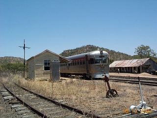
I was recently browsing the Rail Trails Australia website, and was astonished to read that the old line between Lappa to Mt Garnet was a designated rail trail. The train my place of employment operates happens to pass through Lappa each week, so this is my closest local rail trail, until some more are developed closer to Cairns. Being a mere 160 odd km from home, and being a somewhat bleak weekend on the coast, a quick trip was in order for a short exploration mission along a bit of the old alignment.
Lappa is on the Chillagoe Railway (Mungana Line), built by the Chillagoe Railway and Mining company between 1899 and 1901. The name Lappa was originally duplicated as Lappa Lappa. At some stage name Lappa Junction was adopted, but by 1943, the Junction part of the name was dropped, so that the location assumed its current identity simply as Lappa. The approach to Lappa from Mt Garnet involved a considerable descent down a 1:33 grade into the yard, and for this reason a run away spur was provided at the down end of the station. Generally hidden from view, a drought in 2002 allowed a photo of the spur to be taken.
The line to Mt Garnet was opened to a location called Ord, about half way to Mt Garnet, in 1901. The line to Mt Garnet was completed in 1902 and from the beginning, traffic was very light indeed, only requiring a weekly train. The line remained in private ownership until 1914, after which time, QR purchased it. After the depression, traffic increased to two trains per week in 1938, rising to daily trains by 1944. Traffic fluctuated from between three and nine trains per week until it closed in 1961.
After the line was dismantled most of the alignment became the ‘back road’ between Lappa and Mt Garnet. For a back track, the advantage of an old railway alignment becomes very obvious, with the curves and grades very gentle. However it is very narrow, especially through the many cuttings and embankments that are along the line.
The rail trails Australia site has this to say about the track:
This trail goes through magnificent ranges with sweeping views of the isolated countryside. Ancient frangipani and mango tress mark the site of old stations and homesteads. Heritage items include narrow rock cuttings and old stone bridges.
The trail passes through remote areas. There are no services along the trail. Carry plenty of water, food and fuel
This is strictly mountain bike territory, and while I do own such a beast, it has enjoyed an existence on paved roads or well packed gravel trails. This trail was therefore a new experience for me, with the track at first determined to cause me to part company with the bike. Fortunately it failed, but a lot of caution had to be exercised navigating the soft sandy patches, the scours and wash aways and bits of railway infrastructure poking around.
We decided to try and get to the old location of Spinifex Creek for this run, but a… err.. ‘fuelling issue’ on the drive out there caused the loss of about 45 minutes , so the trip was cut back to a bit less than half of the intended distance – 7 of 16 km. When you are not furiously focusing on the track ahead, the ride starts out in some spectacular country, being as you are in the thick of the Lappa Range, with the cuttings and embankments appearing in regular succession. After about 5 km the country eases and levels a little, and better progress can be made on the trail, although you need to be aware of the ever present scours and soft spots. As the rail trail blurb suggests, you need to be pretty self sufficient out there, and as this was a spur of the moment thing, only the short run was nominated, as a sort of a scouting mission. As a back up, a support vehicle was used – and driven by the days photographer Aaron. He is a bit of a per-way enthusiast, so a bunch of the gallery photos are his own little side trips into ditches and culverts to record the interesting infrastructure.
I think this would be a trip well worth doing the whole way across to Mt Garnet. At 55 km, it would take a good days ride, but unlike the pub at Lappa, the one at Mt Garnet is licensed and open for business, so there is reward at the end of the trip. Would need to be carefully planed though, with confirmation that a support vehicle can get through the creeks – apparently there was a lot of damaged caused during the past wet season.
.
View Mt Garnet Branch in a larger map


Greatly appreciate all the time devoted to this blog and the excellent photographs. If only I could return and spend more time investigating this fascinating area. I hope that the photographer was safely carrying all the water ! The bike rider seems to have been travelling “light”. Was explaining to my grand-kids recently how one used to see cars in the outback carrying canvas water bags on the front bumper for “cool” water. It’s such a long time since I was driving in the bush that I wonder if this is still the practice now that we have styrofoam coolers?
Hi Colin – the bike rider was photographed from the adequately provisioned ‘support vehicle’ . These days, the water the air conditioned comfort of most vehicles keeps the water plenty cool. Some are even equipped with fridges etc. So the old canvas water bag is pretty redundant these days, but they are not entirely extinct either.