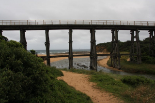
This was trip was not on the original holiday plan, and in it was in fact a last minute and very ad-hoc decision to check this trail out. The plan had to be altered due to the hire bike I ended up with, would not be able to stand up to the original idea of checking out the Erica to Thompson rail trail. So a southerly detour was made to South Gippsland.
After experiencing very warm conditions while travelling down from the North of the State, I should have remembered the sort of weather that only South Gippsland can put on, even in the height of Summer. A mighty wind was blowing in from Bass Strait, complete with low scudding grey clouds and lashing rain. Not really my favourite bike riding weather. The first job was to position the car at the end of the track, at Wonthaggi, so I stopped near the Kilcunda trestle bridge to get some photos of the bleakness. However, by the time I returned to the starting point at Anderson, blue skies had returned with cheery sunshine. The gale was still blowing, and from the direction it was intended to travel, but this was only a 16 km trip, so therefore manageable.
The Wonthaggi line was built in 1910 to support the State Coal mine just out of the town. It also provided a passenger and goods service. The line branched from the South Gippsland Line at Nyora. The VR purchased most of the coal that the mines produced, however with the change from steam to diesel locomotives, demand for the coal declined, and the mine closed in 1968. The last passenger train ran in November 1977, and final closure of the line occurred in 1978. The line was dismantled in 1988.
This train varies from the spectacular to the mundane. The line used to cross the top of the sand dunes near Kilkunda, which makes for absolutely splendid scenery. Once you leave the sea and head inland, you quickly become surrounded by flat and reasonably featureless grazing country, although this is broken up by a few interesting bridges. As you near Wonthaggi, the country side becomes more pleasing with the appearance of trees. Still, it was a thoroughly enjoyable ride, with the breath taking sea-scapes more than making up for the dairy country further along the track.
The feared breeze was not too bad either. The start of the ride is very downhill, and by the time you cross the sand dunes, the wind was more of a cross wind than a head wind. And here, you were protected by vegetation that acted as a very efficient wind break. Except while crossing the bridge of course.
This link will take you the ‘runkeeper’ track map of the ride. There is also a map embedded below the gallery. There are other interesting links at Les Browns Train Pics site, that show old photos of excursions to Wonthaggi in the 60’s, so you can get an idea of what it all looked like when there trains running on the alignment. ARE excursion in 1967, and an ARHS trip in 1968.
.
View Bass Coast Rail Trail in a larger map


