When I used to live in the Western District of Victoria as a yoof, the line from Ballarat to Skipton was still open. The line meandered across the Glenelg Highway a couple of times, but I never did see a train on it in all those times my family traveled that highway towards Ballarat and Melbourne. Up until when I left the district in 1976, there was a rail motor service use to convey kids to school from Skipton and other points along the line. The line closed completely in 1988.
This line was therefore of interest to me, and was the first to be explored on this trip, but only as far as Linton. I didn’t really have the time to do the whole lot, and lets be honest, probably not the fitness either. Skipton had also suffered from it’s own floods, so it was probably better to give the town a miss anyway.
I arrived into Ballarat late on the preceding night, just in time to witness a howling southerly change come through. I actually arrived there from Auckland (NZ) and the wind chill had to be felt to be believed. Brought back plenty of memories, suffice to say!
Early the next morning, I met up with my travelling companion, and my hire bike at Lake Wendouree, saddled up and began the trip from there in sunny but bracing conditions. By the time we got to the start of the trail proper, I was warm enough to remove my coat, and kept busy enough to remain sufficiently warm for the rest of the trip.
The wind was kind to us, tending to be mostly behind us while. The trail is well signed with distance markers, interpretative displays at old station locations, and would normally be a pretty good compacted gravel surface. However, recent heavy rains in Victoria has caused some scouring along the track, and near total washout conditions in some places, meaning a bit of care had to be taken.
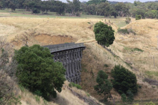
The grades were easy, but there are a couple of decent pulls along the line. It features some pretty fair cuttings and embankments, and one particularly awesome trestle bridge at Newtown (there is a better one beyond Linton). The scenery is really your basic western district agricultural type, although as you near Linton, some impressive forest is passed through.
Haddon, Smythesdale Scaresdale and Newtown are passed during the trip, which have a range of facilities, ranging from shelters and interpretative signes, though to toilets and drinking water.
The trip was recorded on a GPS enabled Android phone, and uploaded directly to ‘Runkeeper‘ – you can go here to view the run data. There is also an Everytrail map of the run here. Les Brown has photos of trains on the line at his train pics site. You find the galleries here and here.
Below the gallery are two maps of the ride… google maps wanted to split them for some reason….
.
Map part 1:
View Ballarat to Linton in a larger map
Map Part 2:
View Ballarat to Linton in a larger map


